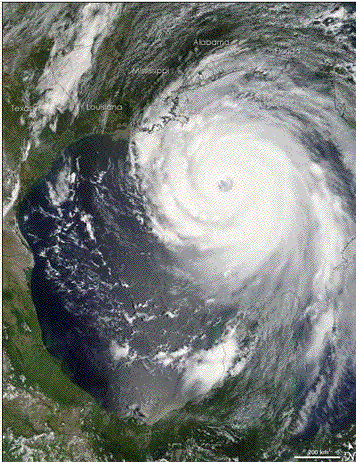
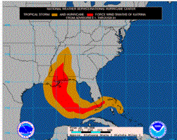
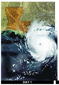
In this experience you are going to make use of resources on the Internet to do research to answer one of several questions about Hurricane Katrina, that came ashore along the Gulf Coast of Louisiana, Mississippi, and Alabama. The NASA photograph shows the size and extent of the hurricane as it was about to come inland. Here you can see how the storm dwarfs individual cities and communities along the coast. The smaller map shows the path of the hurricane and it moved inland into the Ohio Valley, and into the North East.
In the Exploration stage, you are going to investigate a significant problem that related to Hurricane Katrina. You should make use of the direct links related to each question, and the links that are found in the Hurricane Database shown below.
Problems for Investigation
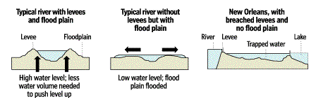
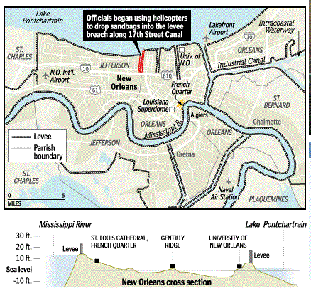
1. Why did New Orleans flood? Below you will find a map, and cross sections of New Orleans, and its relationship to Lake Pontchartrain and the Mississippii River. Notice that the city has a lower elevation than the lake or the river. What caused the city to flood? How could it have been prevented?
2. How did Katrina become a category 5 Hurricane? To answer this question, we need to know how hurricanes originate, how they develop. Generally speaking, 3 - 5 hurricanes hit the coast of the U.S. each year, and can cause considerable damage. Use the following links to answer the basic question in this section.
3. What casues the damage when a Hurricane passes over an area? It might surprise you that it is storm surge that causes the most damage along a coastline. Look into this concept, and find out also how winds impact structures and vegetation.
- The Greatest Danger--Storm Surge
- Hurricane Winds
- Inland Flooding---Devastation in New Orleans
- Max Mayfield, Director National Hurricane Center talks on"flooding"
4. Were warning heeded? It is easy to point the finger at various individuals, government officials and agencies regarding what steps might have been taken to lessen the damage and loss of life. To what extend were warnings heeded about the possibility of a category 4 or 5 hurricane hitting the New Orleans area? Use the Internet to find out what preparations could have been taken and try and evaluate to what extent these preparations were carried out.
- THE TIMES-PICAYUNE Five-Part Series on the Effect of a Hurricane on New Orleans (2002)
- Hurricane Preparedness
5. Criticism of government response. Many individuals have criticized the response of the government to the aftermath of Hurricane Katrina. What are the opinions, and how do you evaluate them? Here are two articles to get you started. Use google.com to search the Internet to find answers and opinions on this question. You might use phrases such as "government response to Katrina," FEMA and Katrina, etc.
Project Database
- New Orleans Hurricane Risk, National Public Radio Audio File, 2002
- CNN Miles O'Brien's Hurricane Katrina Blog
- Hurricane History---maps and descriptions of significant hurricanes
- National Hurricane Center
- Hurricane Katrina
- Katrina Ignites Global Warming Debate
- Terra Server--ariel and topographic views of earth
- Terraserver--Another site for views of earth
- Hurricane Katrina on Terraserver.com